New Notebook
The Evidence of Continental Drift
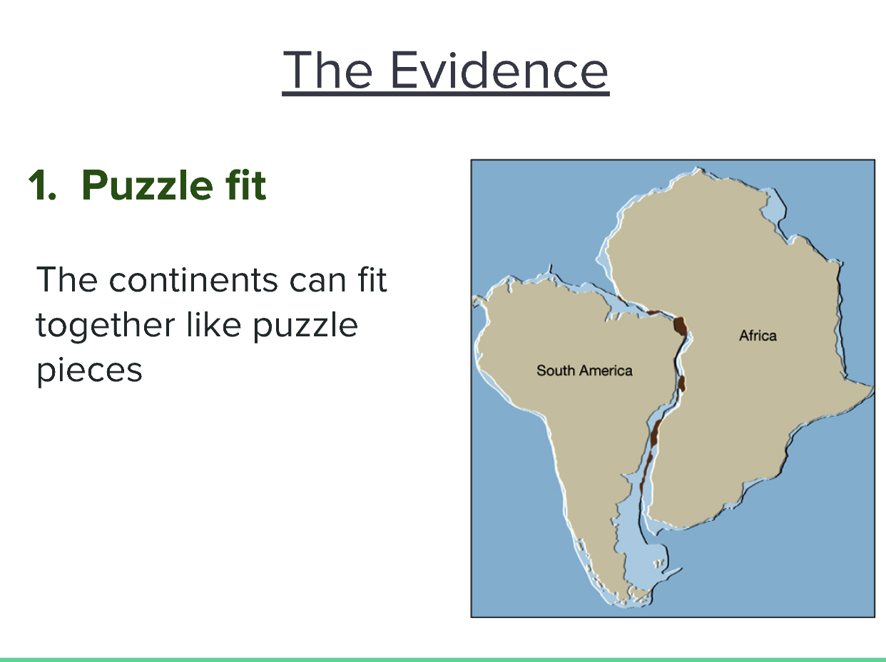
- Puzzle Fit
-
The continents can fit together like puzzle pieces.
- This idea suggests that continents were once joined together and have since drifted apart. The coastlines of South America and Africa show a notable resemblance to interlocking puzzle pieces, which is a significant point supporting the theory of continental drift.
- It implies that the movement of tectonic plates over geological time has altered the arrangement of continents, moving them away from a single landmass known as Pangaea.
-
Additional Context
- This concept was one of the early pieces of evidence proposed by Alfred Wegener in his theory of continental drift. It raises questions about the geological processes that could cause such movements and link continental morphology to historical geological events. This analysis continues to influence the fields of geology and plate tectonics today.
-
To summarize, the image represents the argument for the puzzle fit of continents as evidence of continental drift, pointing to historical connections between landmasses.
Extended readings:
The Evidence of Fossils
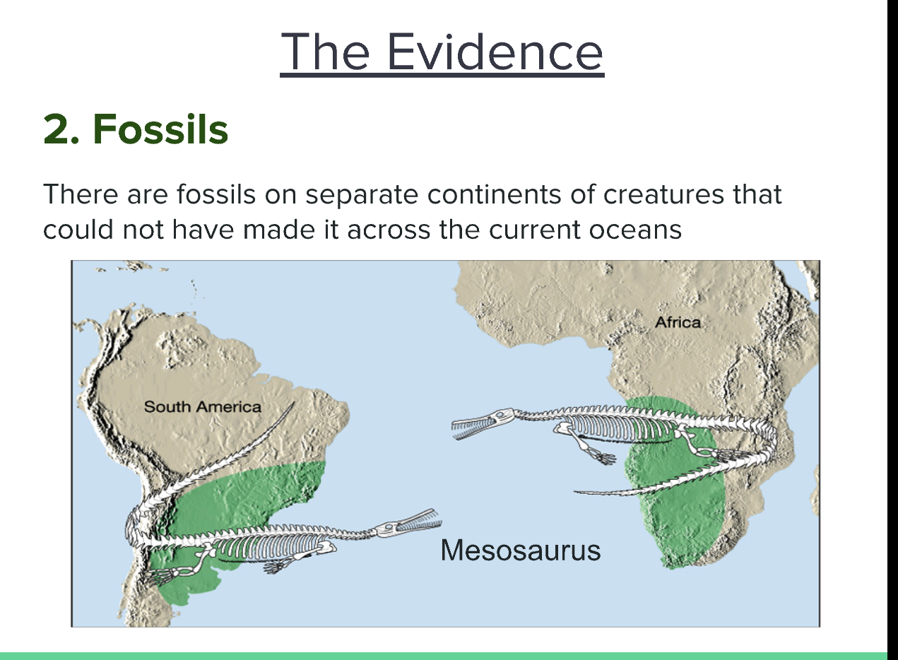
1. Fossil Distribution
- Observation: Fossils of the same species have been found on different continents, specifically South America and Africa.
- Thoughts: This suggests that these continents were once connected or that the species had a much broader range in the past.
- Additional Information: One key example is the Mesosaurus, a freshwater reptile that could not have swum across the vast Atlantic Ocean as it exists today.
2. Implications for Continental Drift
- Observation: The existence of similar fossils on distant continents provides evidence for the theory of continental drift.
- Thoughts: This theory posits that continents are not fixed and have moved over geological time, leading to the current configuration we see today.
- Additional Information: Alfred Wegener, who proposed this theory in the early 20th century, used fossil evidence as one of his main points to support his hypothesis.
3. Importance of Fossil Evidence
- Observation: Fossil evidence is crucial in understanding Earth's geological and biological history.
- Thoughts: It helps scientists piece together the history of life on Earth, how species adapted or became extinct, and how continents rearranged over time.
- Additional Information: Fossils can reveal significant information not only about the organisms themselves but also about the environmental conditions in which they lived.
| Fossil Example | Continents Found | Significance |
|---|---|---|
| Mesosaurus | South America, Africa | Evidence for continental drift theory |
Extended readings:
Earthquakes and Volcanoes
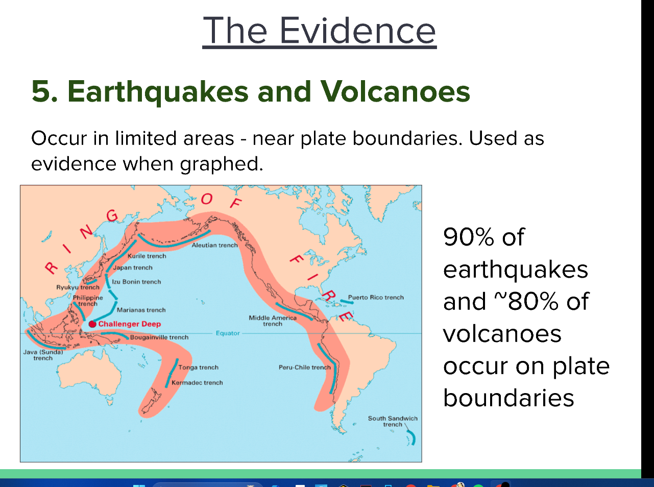
Key Points
-
Occurrence Near Plate Boundaries
- Earthquakes and volcanoes are predominantly found in limited geographic areas, particularly near tectonic plate boundaries. This relationship highlights how the movement and interactions of tectonic plates contribute to geological activity.
-
The Ring of Fire
- The image illustrates the "Ring of Fire," a major area in the basin of the Pacific Ocean where a large number of earthquakes and volcanic eruptions occur. This region is characterized by a high degree of tectonic activity due to the movement of several tectonic plates.
-
Statistics
- Approximately 90% of earthquakes and around 80% of volcanoes are located along plate boundaries. This statistic emphasizes the importance of understanding plate tectonics in comprehending geological hazards.
Additional Thoughts
-
Plate Dynamics
- The dynamics between converging, diverging, and transforming plate boundaries create stress that eventually leads to earthquakes and volcanic activity. Each type of boundary has distinct geological features and risks associated with them.
-
Implications for Humans
- Understanding the relationship between tectonic plates and geological events is crucial for disaster preparedness and risk management in areas prone to earthquakes and volcanic eruptions. Enhanced predictive models and construction practices can save lives and minimize damage.
Summary
This image presents evidence regarding the occurrence of earthquakes and volcanoes, predominantly in areas near tectonic plate boundaries. The "Ring of Fire" is specifically highlighted as a hotspot for both phenomena, underscoring the significance of tectonic activities in shaping the planet's geological landscape.
Extended readings:
Ages of Rocks at Rift/Ridge Zones
-
Rocks Age Gradient:
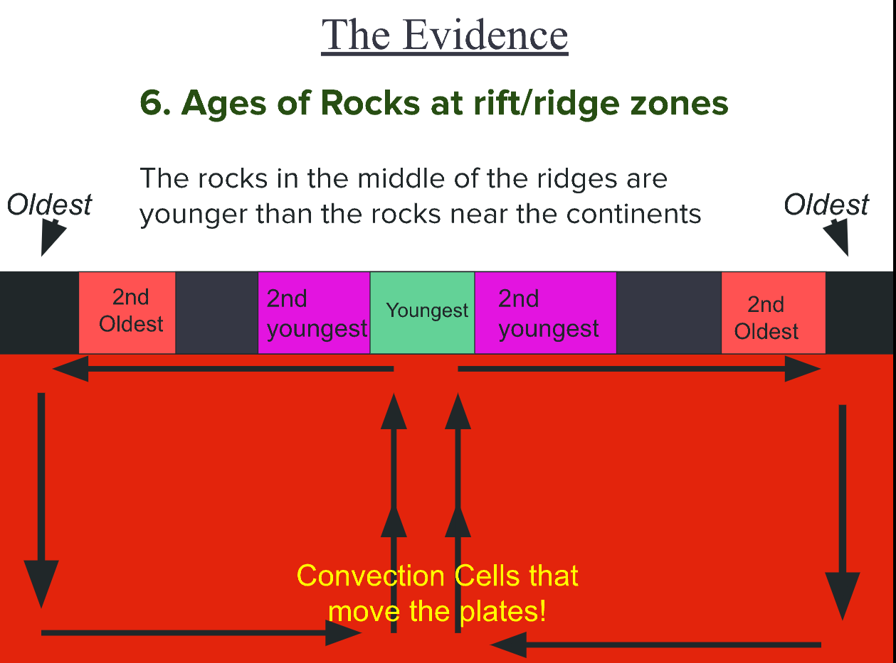
- The rocks located in the center of mid-ocean ridges are younger compared to the rocks that are found nearer to the continents.
- This pattern is vital for understanding the process of seafloor spreading. As tectonic plates pull apart at these ridges, magma rises to fill the gap, creating new oceanic crust.
-
Oldest vs. Youngest Rocks:
- In the diagram, the rocks are arranged in a gradient from oldest to youngest, indicating that new rock is formed at the center and gradually moves outward.
- Age Order:
- Oldest
- 2nd Oldest
- 2nd Youngest
- Youngest
- 2nd Youngest
- 2nd Oldest
- Oldest
| Age | Position |
|---|---|
| Oldest | Outer layers |
| 2nd Oldest | Adjacent to Oldest |
| 2nd Youngest | Near the center |
| Youngest | Center of ridges |
| 2nd Youngest | Near the center |
| 2nd Oldest | Adjacent to Oldest |
| Oldest | Outer layers |
-
Convection Cells:
- The image mentions "Convection Cells that move the plates," which refers to the process of convection in the mantle.
- These convection currents are crucial for the movement of tectonic plates. As hot material rises and cooler material sinks, it causes the plates to move, leading to geological activity such as earthquakes and volcanic eruptions.
-
Significance:
- Understanding the age distribution of rocks at rift zones helps scientists to determine the history and dynamics of plate tectonics, as well as the processes that lead to the formation of new oceanic crust.
- This knowledge is essential for various geological studies, including those related to natural resource exploration and earthquake prediction.
Extended readings:
Mid-Ocean Ridge and Crust Formation
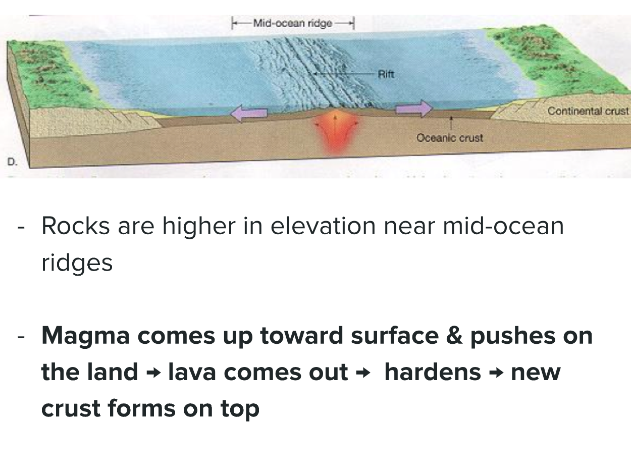
-
Rocks are higher in elevation near mid-ocean ridges
- Mid-ocean ridges are underwater mountain ranges formed by tectonic activity. The elevation is due to the upwelling of magma, which creates new crust, causing the rocks around the ridge to be elevated compared to the surrounding ocean floor. This geological feature is significant for understanding plate tectonics.
-
Magma comes up toward surface & pushes on the land → lava comes out → hardens → new crust forms on top
- The process begins with magma rising from the mantle due to convection currents and tectonic plate movements. As it reaches the surface, it erupts as lava. Upon cooling, the lava solidifies, contributing to the expansion of the oceanic crust. This ongoing cycle is crucial in the formation of new crust and the dynamic nature of the Earth’s surface. It also plays a role in the creation of features like volcanic islands and seafloor spreading.
Extended readings:
Ocean Floor Magnetic Bands
-
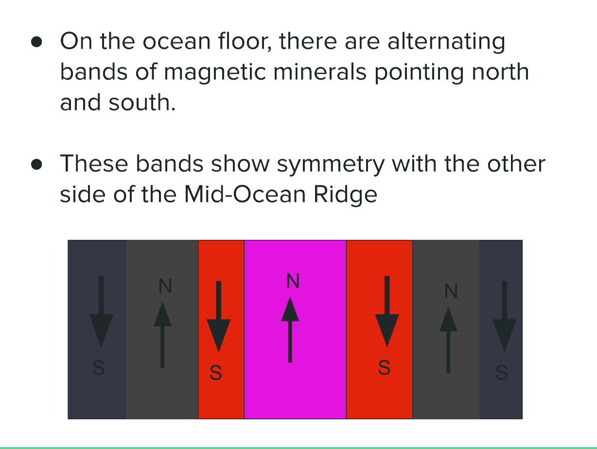
Alternating Bands of Magnetic Minerals
- The ocean floor consists of bands of magnetic minerals that exhibit alternating polarities, with some pointing north and others south.
- This phenomenon occurs due to the Earth's magnetic field reversing over geological time scales, which gets recorded in the minerals as magma cools and solidifies at mid-ocean ridges.
-
Symmetry with the Other Side of the Mid-Ocean Ridge
- The observed symmetry of these bands on either side of the Mid-Ocean Ridge supports the theory of seafloor spreading.
- As tectonic plates move apart, new material emerges from the mantle, creating new oceanic crust that mirrors the magnetic patterns of the opposite side.
- This symmetry is a key piece of evidence for the theory of plate tectonics, helping scientists understand the dynamic nature of Earth's geology.
Visualization Summary
- The image shows bands with alternating magnetic orientations, denoted as "N" for north and "S" for south, with a notable central band in a different color indicating a peak or boundary.
Extended readings:
History of Plate Tectonics

-
Late 1500s - 1700s:
- Scientists observed a puzzle-like fit between continents.
- This observation laid the groundwork for later theories regarding continental drift.
-
1912:
- German scientist Alfred Wegener proposed the theory of continental drift, backing it with evidence such as fossil similarities across continents and the fit of their coastlines.
- Wegener's work emphasized that continents were not static; they moved over geological time.
-
1912-1960:
- Despite its insight, Wegener’s theory faced significant skepticism and ridicule from the scientific community, primarily due to a lack of a mechanism explaining how continents could move.
- This period reflects the challenges of introducing novel ideas into established scientific paradigms.
-
1968:
- The theory of continental drift was finally accepted, aided by research from scientists like John Tuzo Wilson who contributed to the understanding of plate tectonics and the mechanisms of plate movement.
- This acceptance marked a turning point in geology, leading to a unified theory that explained various geological phenomena.
| Year | Event | Additional Information |
|---|---|---|
| Late 1500s - 1700s | Noticed puzzle-like fit between continents | Early observations that prompted later theories. |
| 1912 | Wegener proposed continental drift | Introduced concepts of fossil evidence and continental fit. |
| 1912-1960 | Wegener's theory ridiculed | Highlighted resistance to new scientific ideas without concrete mechanisms. |
| 1968 | Theory accepted, aided by Tuzo Wilson | Established a comprehensive understanding of tectonic movements. |
Extended readings:
Rock Formations Evidence
-
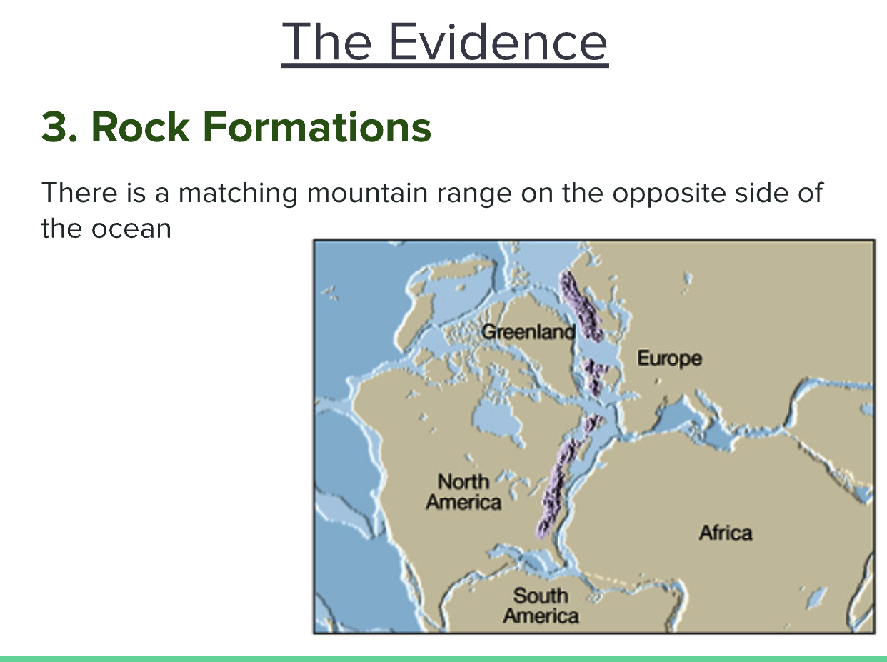
Matching Mountain Range
- Observation: There exists a mountain range on the opposite side of the ocean that aligns with the formation shown in the image.
- Thoughts: This observation supports the theory of continental drift, proposing that continents are not fixed but have moved over geological time.
- Additional Information: The similarity in rock formations between continents is often used to demonstrate that they were once joined. For example, the Appalachian Mountains in North America are geologically similar to the Caledonian Mountains in Scotland.
-
Geological Implications
- Observation: The continuity of rock formations across oceans suggests past geological connections.
- Thoughts: These findings imply that the geological history of continents can provide insights into past continental configurations.
- Additional Information: Studies of plate tectonics use such evidence to reconstruct the Earth's ancient supercontinents, like Pangaea.
-
Visual Representation
- Observation: The map illustrates the geologically similar mountain ranges.
- Thoughts: Visual aids like maps are crucial for comprehending broad geological concepts, such as plate movements and continental relationships.
- Additional Information: Geological maps often highlight the distribution of rock types and structures, which can help predict resource locations and assess geological hazards.
-
Relation to Previous Evidence
- This evidence ties into previous notes regarding alternating magnetic minerals and fossil distribution, reinforcing the overall narrative of plate tectonics and continental drift theories. The alignment of rock formations further bolsters the argument that Earth's landmasses were once connected.
Extended readings:
Glacial Evidence of Continental Drift
-
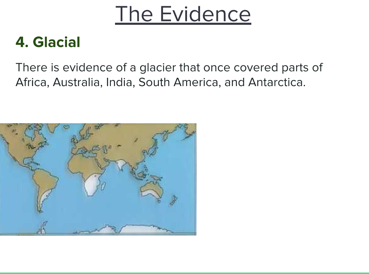
Glacial Coverage Evidence
- Thoughts: The presence of ancient glacial formations on multiple continents suggests a significant change in climate and geography over millions of years.
- Additional Information: This evidence indicates that parts of Africa, Australia, India, South America, and Antarctica were once connected in a single landmass, likely during the time of Pangaea, where warmer climates were prevalent in some areas now covered in ice.
-
Affected Continents
- Continents listed:
- Africa
- Australia
- India
- South America
- Antarctica
- Thoughts: These continents exhibit similar glacial striations and sedimentary deposits that point to prior glacial activity, supporting the idea of past climate coherence across these regions.
- Additional Information: This type of evidence aligns with the theory of continental drift, highlighting how continents can have shared geological histories despite their current separation.
- Continents listed:
-
Implications for Climate Change
- Thoughts: The discovery of glacial remnants in currently warm regions indicates past climate shifts and supports studies on how global climate has fluctuated over geologic time.
- Additional Information: Understanding these shifts can provide insight into current climate change trends and the Earth's climate system's dynamics.
-
Connection to Previous Notes
- This glacial evidence complements other points on the theory of continental drift, such as the puzzle fit of continents, fossil distribution, and mid-ocean ridge formations.
- The combined evidence strengthens the argument for a connected past among these diverse landmasses, revealing interconnected geological and climatic histories.
Extended readings:
Geological Characteristics of Ridges
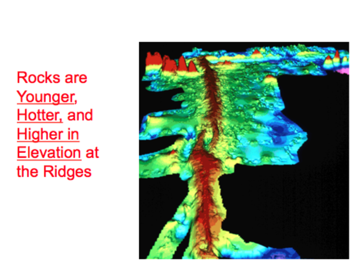
-
Rocks are Younger at the Ridges
- This indicates that the geological activity at ridges leads to the formation of new rocks. As tectonic plates diverge, magma rises and solidifies to create fresh crust. This process provides insight into the dynamic nature of Earth's lithosphere and reinforces the concept of plate tectonics.
-
Rocks are Hotter at the Ridges
- The heat found at ridges is primarily due to the upwelling of magma from the mantle. This geothermal energy contributes to higher temperatures in these areas, which can influence local ecosystems and geological processes. It also indicates ongoing volcanic activity and heat flow from the Earth's interior.
-
Rocks are Higher in Elevation at the Ridges
- The topography of mid-ocean ridges is characterized by elevated features compared to surrounding seabeds. This elevation is a result of the buoyant, less dense newly formed crust. This physical characteristic influences ocean currents and can affect climate patterns over geological timescales.
-
General Summary
- The image highlights the geological characteristics of ridges, emphasizing the relationship between rock age, temperature, and elevation. These factors are critical in understanding tectonic plate movements, geological processes at mid-ocean ridges, and the formation of new oceanic crust, which collectively support theories of continental drift and the structure of Earth's lithosphere.
Extended readings:
Magnetism
Magnetic Minerals in Rocks
- Some rocks, specifically igneous rocks, contain magnetic minerals like magnetite.
- Thoughts: The presence of these minerals can provide insights into the past geological conditions and the magnetic field at the time of the rock's formation.
- Additional Info: Magnetite is a naturally magnetic mineral that can retain historical magnetic information.
Alignment of Magnetic Minerals
- As crystals form in cooling lava, magnetic minerals align themselves with Earth's magnetic field, pointing toward the North and South poles.
- Thoughts: This alignment helps geologists understand the orientation of the magnetic field when the rock cooled, which can be crucial for reconstructing past movements of tectonic plates.
- Additional Info: This process occurs during the solidification of lava, captured in igneous rock formations.
Reversal of Earth's Magnetic Poles
- Reversal of Earth's magnetic poles occurs approximately every 1 million years.
- Thoughts: These reversals can have significant impacts on navigation and animal migration, given that many species rely on the magnetic field for orientation.
- Additional Info: Geological records help scientists track these reversals, contributing to our understanding of Earth’s geological history and the dynamics of the Earth's core.
Extended readings: